Eleven kilometres of narrow land separate the Venetian Lagoon from the Adriatic Sea: this is Pellestrina, an island where the history of Venice can be read in fishing boats, coastal stone walls and families whose surnames still identify entire neighbourhoods. Far from the grand palaces of the historic centre, Pellestrina has long been a place of hard work, maritime knowledge and daily coexistence with the sea.
The history of Pellestrina island is especially important for understanding how Venice protected its lagoon. Its communities survived the War of Chioggia, developed distinctive fishing and lace-making traditions, and depended on the imposing eighteenth-century Murazzi—sea defences dramatically tested by the flood of 1966.
Where is Pellestrina in the Venetian Lagoon?
Pellestrina is a long, narrow barrier island south of the Lido of Venice and north of Chioggia. On its western side lie the calm waters, channels and fishing grounds of the southern Venetian Lagoon; on its eastern side is the open Adriatic Sea. The island extends for approximately 11 kilometres, although its width changes considerably along its length.
The inhabited settlements, including Santa Maria del Mare, San Pietro in Volta, Portosecco and Pellestrina, face mainly towards the lagoon. On the opposite shore the Murazzi and other coastal works defend the strip of land against storms and erosion.
Its geography explains much of its character. Water has always provided food and transport, but the same environment makes the island vulnerable to strong winds, waves, high tides and changes in coastal sediment.
The early lagoon and the settlement of Albiola
The island’s history reaches back to the development of settlements across the lagoon in late antiquity and the early Middle Ages. The presence of boats, fisheries, trading routes and agricultural land made the coastal strip valuable long before Venice assumed its later political importance.
Historical reconstructions refer to an early settlement called Albiola, recorded around 840 and located in the area of present-day San Pietro in Volta. The ancient harbour was associated with the Medoacus Minor, a branch of the Brenta River. These descriptions are based on fragmentary evidence, and the precise geography of the early shoreline cannot be reconstructed as if it were unchanged.
Over time sedimentation altered the channels and contributed to the disappearance of navigable openings. The toponym Portosecco, literally “dry port”, is traditionally connected with the silting-up of a former harbour. The story reveals how changing waterways could reshape entire communities.
The name Pellestrina and the island’s uncertain etymology
Several explanations have been proposed for the name Pellestrina. Some local traditions connect it to early place names and personal names; others rely on imaginative stories about the appearance or occupations of its inhabitants.
There is no single universally accepted etymology that can be presented as certain. What matters historically is that the coastal community was clearly distinguished within the Venetian lagoon system and gradually developed its own institutions and traditions.
Its inhabitants are often called pellestrinotti, a name still expressing a strong relationship with the island and its maritime life.
The Middle Ages: fishing, orchards, vineyards and local government
Before Pellestrina became famous for its sea walls, its inhabitants relied on a mixture of fishing, agriculture and lagoon commerce. Medieval documents also describe coastal properties belonging to Venetian families, including gardens, vines, fisheries and areas used for hunting.
Transport by water was essential. Food, materials and people moved between Pellestrina, Chioggia, the Lido and Venice on different types of lagoon boats. The community also followed administrative arrangements linked to the authorities of the Venetian Republic.
Land was never completely separate from water. Coastal erosion, shifting sand and storm damage could threaten buildings and cultivation, making the maintenance of embankments a continuing responsibility.
1379–1380: the War of Chioggia devastates Pellestrina
The War of Chioggia, fought between Venice and Genoa in 1378–1381, marked a turning point. The fighting reached the southern lagoon, and Pellestrina suffered severe destruction during the Genoese occupation and associated military operations.
Following the Venetian victory, the island faced the challenge of reconstructing homes and restoring its economy. According to official Venetian historical accounts, the doge Andrea Contarini visited Pellestrina in July 1380 to acknowledge the contribution and resilience of its population.
Later local histories sometimes present the reconstruction as the work of four families alone, but the fuller story also includes the efforts of islanders who remained and returned after the conflict.
The four families and Pellestrina’s historic sestieri
After the war, four families associated with Chioggia helped repopulate and reorganise the settlement: Scarpa, Zennaro, Vianello and Busetto. Their names survive in the four historic sestieri of the main village.
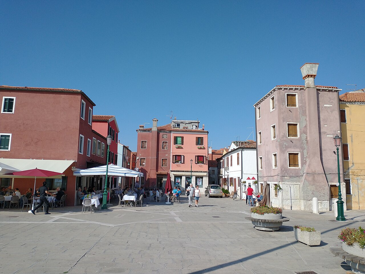
From north to south, official Venezia Unica and the City of Venice identify the districts as Scarpa, Zennari, Vianelli and Busetti. The surviving family names remain common, although their spelling can vary between a family surname and the name of a district.
These districts are more than picturesque labels on street signs. They illustrate the continuity of local identity after the late-medieval reconstruction and the way in which family history became part of the island’s geography.
San Pietro in Volta: one of the island’s oldest communities
At the northern end of the island, San Pietro in Volta retains a distinctive character with low houses, boats, vegetable gardens and a church rebuilt in the eighteenth century. Historical and linguistic research by the Municipality of Venice places the development of this settlement and nearby Portosecco in the centuries following the War of Chioggia.
Local family names and dialect words preserve memories of fishing activities, tools and everyday relationships that are not always visible in official state history. Their study is an important part of the island’s intangible cultural heritage.
San Pietro in Volta also houses the Piccolo Museo della Laguna Sud, an institution devoted to recovering documents, photographs and accounts of Pellestrina’s working life.
Portosecco and the tradition of bobbin lace
The village of Portosecco is known for an important tradition of bobbin lace, worked on a tombolo using wooden bobbins. Historically, women could practise this skill at home or while gathering with neighbours, making needlework part of social and family life.
It is useful to distinguish Pellestrina’s lace tradition from the better-known needle lace of Burano. Both belong to Venetian textile heritage, but the techniques and tools are not identical. Burano became particularly associated with intricate needlework, while the bobbin technique is characteristic of Portosecco.
The craft also had an economic dimension: carefully made lace could supplement family income in a community where fishing was seasonal and exposed to unpredictable weather.
Fishing: a working relationship with the lagoon
For centuries the heart of Pellestrina’s economy has been fishing. Knowledge of tides, fish migration, channels and seasonal changes was passed between generations, often within families who owned or worked on their own boats.
Fishing techniques ranged from work in shallow lagoon waters to activities extending into the Adriatic. Nets, traps and different boat types were used depending on the species and the fishing grounds. The catch was transported to local markets and other parts of the Venetian lagoon.
Fishing is still important today, but modern ecological regulations, fuel costs and changing marine conditions make it a complex profession. An article about Pellestrina should recognise the working community rather than presenting fishermen merely as part of a postcard image.
The sanpierota boat and the island’s shipbuilding tradition
The sanpierota is a traditional Venetian lagoon boat whose name recalls San Pietro in Volta. Its practical design developed around the needs of the lagoon: shallow water, transport of fishing equipment and manoeuvrability in canals and tidal channels.
The work of local maestri d’ascia, or master boatbuilders, preserved knowledge of timber construction, hull shape and the maintenance of small working craft. Some of these boats later became valued by enthusiasts of traditional Venetian rowing.
Historically, boatbuilding and fishing were connected forms of expertise. The boats used by the community were adapted to local conditions rather than chosen solely for their appearance.
Why did Venice need the Murazzi sea walls?
From the Middle Ages onwards, Venice attempted to defend its fragile barrier islands from the Adriatic. Early barriers used timber piles, stones and other materials. These defences required frequent repair and could be overcome by powerful storms.
The Republic understood that Pellestrina was not simply another coastal settlement: the thin island acted as a natural barrier protecting the lagoon and Venice itself. If the barrier failed, the sea could alter the waters, channels and settlements behind it.
The solution was a more ambitious system of coastal engineering, designed to resist wave action and give the shoreline greater stability. The resulting Murazzi became one of the greatest hydraulic works of eighteenth-century Venice.
Bernardino Zendrini and the eighteenth-century engineering project
The mathematician and engineer Bernardino Zendrini (1679–1747) played a central role in developing the new sea walls. As an expert in the water management of the Venetian Republic, he advocated a more durable structure using large blocks of Istrian stone joined with hydraulic mortar containing pozzolana.
This material was essential because it allowed the mortar to harden and maintain strength in wet conditions. The earlier systems of loose stone and timber had been inadequate against the sustained force of the Adriatic.
According to the Treccani history of Venetian lagoon management, work began around 1737. On the Pellestrina coast an important construction phase ran from 1744 to 1755 for approximately four kilometres, while later additions included works near Chioggia in 1782.
The dates sometimes quoted as 1744–1782 refer to different phases of a wider system, not to one uninterrupted construction campaign on every stretch of Pellestrina.
How the Murazzi changed the shape of Pellestrina
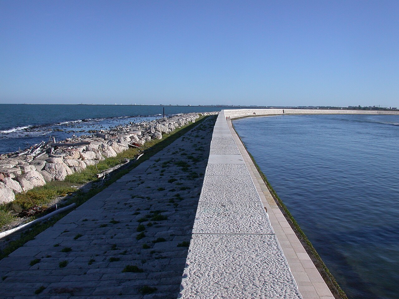
The Murazzi created an imposing stone coastal defence between the settlements and the sea. Their robust sloping surfaces and carefully fitted blocks were intended to break and resist waves rather than allow them to attack the fragile land directly.
Further engineers, including Tommaso Temanza and Anton Mario Lorgna, contributed to studies and modifications. Other works were added or altered over time, depending on changes to beaches and the seabed.
The stone walls changed the daily relationship between islanders and the Adriatic. For the inhabitants they were both a vital safeguard and a powerful reminder that the sea could never be taken for granted.
4 November 1966: the storm that broke the defences
On 4 November 1966, an exceptional storm and high-water event struck Venice and its coastal barrier islands. At the Punta della Salute gauge, Venice reached a tide level of 194 centimetres, a historic record for the city. This figure refers to the Venice gauge, not to a separate measurement taken on Pellestrina.
On Pellestrina, powerful Adriatic waves overtopped the Murazzi and caused breaches in several places. Seawater flooded inhabited areas, damaging homes, roads and essential infrastructure. The emergency became one of the strongest shared memories of the island’s twentieth-century history.
Contemporary descriptions and later studies confirm that the 1966 event demonstrated the limits of a defence system designed in very different environmental conditions. Repairs and major reinforcement projects followed.
After 1966: restoring the coast and protecting the island
The decades after the flood brought a renewed focus on coastal protection. Historic stone works were reinforced, while other interventions included rock barriers, groynes, beach nourishment and protection of the seabed.
These measures were designed to reduce erosion and wave energy, protecting both the island and the wider lagoon. Coastal engineering must continually respond to shifting sediment, water levels and storms; even monumental structures such as the Murazzi are part of a wider dynamic system.
Today the seawalls form a defining part of Pellestrina’s landscape. They should be understood as historic heritage and working protective infrastructure, rather than simply as a place for photographs or a seaside walk.
Madonna dell’Apparizione: the religious tradition of 1716
One of Pellestrina’s most enduring religious traditions concerns the Madonna dell’Apparizione. According to the accounts maintained by the Diocese of Chioggia, on 4 August 1716 a boy named Natalino Scarpa reported an apparition of the Virgin Mary near the small oratory of Saints Vito and Modesto.
The story became associated with the Republic’s military struggle against the Ottoman Empire. A sanctuary was subsequently built, with the foundation stone laid in 1718, and the annual celebration on 4 August remains part of the island’s religious identity.
This event should be described as a religious tradition and an account recognised within the local devotional history, rather than as a scientifically verifiable phenomenon. The sanctuary and its festivities illustrate the strength of local religious and communal ties.
The Piccolo Museo della Laguna Sud: preserving local memory
In San Pietro in Volta, the Piccolo Museo della Laguna Sud occupies the former Carlo Goldoni school. Its collections and research focus on photographs, documents, oral testimony, working tools and the social history of Pellestrina.
The museum tells the story of the Murazzi, the catastrophic flood, fishing and the traditions of the lagoon. It is particularly valuable for visitors who want to understand local life from the perspective of residents rather than only through the history of the Venetian Republic.
The museum’s official visitor page publishes its seasonal opening programme. In November 2026 the regular April-to-November weekend season has ended, but group visits can be requested by arrangement; always confirm availability directly.
Ca’ Roman: dunes, birds and the protected southern shore
At the southern end of the coastal system lies the Ca’ Roman Nature Reserve, managed by LIPU. Its beach, dunes and woodland protect a rare fragment of northern Adriatic coastal habitat.
The protected area is a significant resting place for migratory birds and an important breeding environment for threatened species such as the Kentish plover (fratino) and little tern (fraticello). LIPU describes the reserve as covering approximately 48 hectares and documents its importance for birdlife.
Access to sensitive areas is regulated, particularly during nesting periods. Visitors should remain on designated routes, respect protective signs and avoid disturbing wildlife. The reserve is an environmental destination, not a place for unrestricted landing, beach activities or motorboat access.
What Pellestrina is like today: a living fishing community
Today Pellestrina remains a place of residential neighbourhoods, working fishing boats, artisan traditions and small local businesses. The lagoon-facing houses and the long line of seawalls give the island a character unlike the monumental Venice of canals and palaces.
Cooking traditions reflect the catch from the lagoon and Adriatic, including fish, shellfish and dishes shaped by coastal life. Gardens and small agricultural plots have also played a part in the island’s economy.
The island’s atmosphere is often described as quiet or timeless, but its history is anything but static. Coastal defence, fishing regulations and environmental change continue to shape the lives of its residents.
How to reach Pellestrina from Venice or Chioggia
Public transport connections require more planning than a visit to central Venice. From Venice, travellers normally reach the Lido and continue with ACTV line 11, which includes bus and ferry connections across the Alberoni–Santa Maria del Mare crossing. From Chioggia, line 11 provides a boat connection across the southern lagoon.
Services, interchange arrangements and timetables can change, so consult the official ACTV navigation timetable rather than relying on an older itinerary.
The island can be explored on foot or by bicycle along the public roads and paths. The long, narrow shape makes distances significant, so plan the direction and timing of a visit with care.
Discover the southern lagoon and Pellestrina by private boat
Approaching Pellestrina by water connects its history to the landscape that shaped it. Fishing villages face the sheltered lagoon, while beyond the narrow strip of land the Murazzi confront the Adriatic. It is a powerful way to understand why the Republic devoted so much engineering and financial effort to protecting its islands.
Explore our Southern Venetian Lagoon by Private Boat experiences or contact us to discuss a customised itinerary. A possible visit to Pellestrina, choice of landing and duration must be agreed in advance and depend on navigation and weather conditions.
For the wider setting, discover our nature experiences in the Venetian Lagoon and the history of Poveglia, another island with a very different past.
Continue reading in our History of the Venetian Lagoon Islands collection.
Frequently asked questions
Why is Pellestrina important to the history of Venice?
Pellestrina is a long barrier island protecting the southern Venetian Lagoon from the Adriatic. Its fishing communities and the eighteenth-century Murazzi coastal defences played a major role in lagoon history.
When were the Murazzi of Pellestrina built?
The engineering project began in the eighteenth century under Bernardino Zendrini. Major works on Pellestrina took place between 1744 and 1755, while other sections of the wider coastal system were completed later.
What happened to Pellestrina in the 1966 flood?
On 4 November 1966, exceptionally powerful waves overtopped and breached sections of the Murazzi, flooding inhabited parts of the island. The disaster prompted major coastal protection work.
Can you visit Pellestrina on a private boat tour?
A private itinerary in the southern Venetian Lagoon can be discussed with the operator. Navigation, landing points, weather and the length of the journey must be agreed in advance; protected habitats such as Ca’ Roman have additional restrictions.
Explore the lagoon by boat: discover our private boat tour in the Venetian Lagoon. Routes are customisable; stops and island access depend on permissions and navigation conditions.
Historical sources and photo credits
Sources: Venezia Unica – Pellestrina; City of Venice – the island and its history; Treccani – coastal engineering and the Murazzi; BEIC – Bernardino Zendrini; Piccolo Museo della Laguna Sud; LIPU – Ca’ Roman; Diocese of Chioggia – Madonna dell’Apparizione. Featured photo: MOs810 / Wikimedia Commons, CC BY-SA 4.0; resized to 1280 px. Other photos are credited in their captions.